Borneo seen from space
Borneo (Malay: Borneo, Indonesian: Kalimantan) is the third largest island in the world and is located north of Java Island, Indonesia, at the geographic centre of Maritime Southeast Asia.
The island is divided among three countries: Brunei, Indonesia and Malaysia. Approximately 73% of the island is Indonesian territory. The Malaysian states of Sabah and Sarawak in the north occupy about 26% of the island. The sovereign state of Brunei, located on the north coast, comprises about 1% of Borneo's land area. Older than the Amazon rainforest, Borneo is the oldest rainforest in the world at 130 million years old. [1]
Contents[] |
[edit] Geography[]
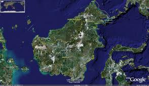
[1][2]Mount KinabaluBorneo is surrounded by the South China Sea to the north and northwest, the Sulu Sea to the northeast, the Celebes Sea and the Makassar Strait to the east, and the Java Sea and Karimata Strait to the south. It is the largest island in the Malay archipelago, with an area of 743,330 square kilometres (287,000 sq mi). To the west of Borneo are the Malay Peninsula and Sumatra. To the south is Java. To the east is Sulawesi, and to the northeast, the Philippines.
Borneo's highest point is Mount Kinabalu in Sabah, Malaysia, with an elevation of 4,095 m (13,435 ft) above sea level. It is the third highest peak in South East Asia, making Borneo the world's third highest island.
The largest river system is the Kapuas in West Kalimantan. With a length of 1,143 km (710 mi), it is the longest river in Indonesia. Malaysia's longest river, the Rajang, lies in Sarawak and is 562.5 km (349.5 mi) long. Other major rivers include the Barito in South Kalimantan (880 km long (550 mi)) and the Mahakam in East Kalimantan (980 km long (610 mi)).
Borneo has significant cave systems. Clearwater Cave, for example, has one of the world's longest underground rivers. Deer Cave is home to over three million bats, with guano accumulated to over 100 metres (330 ft) high.[2]
[edit] Largest cities[]
The following is a list of top 20 urban areas in Borneo by population based on 2010 calculations compiled by The World Gazetteer.[3][4]
| Rank[3] | City/Town[4] | Population[5] | Country[6] |
|---|---|---|---|
| 1 | Kuching, Sarawak | 658,549 | Malaysia |
| 2 | Banjarmasin, South Kalimantan | 611,730 | Indonesia |
| 3 | Kota Kinabalu, Sabah | 604,078 | Malaysia |
| 4 | Sandakan, Sabah | 501,193 | Malaysia |
| 5 | Pontianak, West Kalimantan | 472,316 | Indonesia |
| 6 | Balikpapan, East Kalimantan | 458,434 | Indonesia |
| 7 | Tawau, Sabah | 381,736 | Malaysia |
| 8 | Samarinda, East Kalimantan | 350,050 | Indonesia |
| 9 | Miri, Sarawak | 280,518 | Malaysia |
| 10 | Loa Janan, East Kalimantan | 238,437 | Indonesia |
| 11 | Palangkaraya, Central Kalimantan | 213,590 | Indonesia |
| 12 | Sibu, Sarawak | 210,879 | Malaysia |
| 13 | Bintulu, Sarawak | 199,514 | Malaysia |
| 14 | Lahad Datu, Sabah | 128,589 | Malaysia |
| 15 | Keningau, Sabah | 120,578 | Malaysia |
| 16 | Bontang, East Kalimantan | 113,933 | Indonesia |
| 17 | Singkawang, West Kalimantan | 108,966 | Indonesia |
| 18 | Tarakan, East Kalimantan | 103,038 | Indonesia |
| 19 | Putatan, Sabah | 88,709 | Malaysia |
| 20 | Labuan, Wilayah Persekutuan | 81,151 | Malaysia |
[edit] Administration[]
[7][8]Political divisions of BorneoThe island of Borneo is divided administratively by three countries. It is the only island in the world so divided (because although Scotland, England, and Wales are traditionally separate countries, they are today united in a federal entity, the UK):
- The Indonesian provinces of East, South, West and Central Kalimantan
- The Malaysian states of Sabah and Sarawak (the Federal Territory of Labuan is located on nearshore islands of Borneo, but not on the island of Borneo itself)
- The independent country of Brunei (main part and eastern exclave of Temburong)
| Federal State or Province[9] |
Capital[10] | Part of country[11] | Area km2[12] |
Area %[13] |
Population | Population | Population %[16] |
|---|---|---|---|---|---|---|---|
| Brunei | Bandar Seri Begawan | Independent Sultanate | 5,770 | 0.77 | 320,000 | 406,200(2009 est)[7] | 2.1 |
| Sarawak | Kuching | Malaysia | 124,450 | 16.6 | 2,012,616 | 2,420,009 | 12.2 |
| Sabah | Kota Kinabalu | Malaysia | 73,619 | 9.8 | 2,449,389 | 3,120,040 | 15.7 |
| Labuan 2) | Victoria | Malaysia Federal territory |
92 | 0.01 | 70,517 | 85,272 | 0.4 |
| Malaysian Borneo | Malaysia | 198,161 | 26.4 | 4,532,522 | 5,625,321 | 28.4 | |
| West Kalimantan | Pontianak | Indonesia | 146,760 | 19.5 | 4,034,198 | 4,393,239 | 22.2 |
| Central Kalimantan | Palangkaraya | Indonesia | 152,600 | 20.3 | 1,855,473 | 2,202,599 | 11.1 |
| South Kalimantan | Banjarmasin | Indonesia | 37,660 | 5.0 | 2,984,026 | 3,626,119 | 18.3 |
| East Kalimantan | Samarinda | Indonesia | 210,985 | 28.1 | 2,455,120 | 3,550,586 | 17.9 |
| Kalimantan | Indonesia | 548,005 | 72.9 | 11,328,817 | 13,772,543 | 69.5 | |
| Borneo | - | 3 countries | 751,936 | 100.0 | 16,196,924 | 19,804,064 | 100.0 |
1) Brunei: Census of Population 2001 2) islands administered as Borneo, geologically part of Borneo, on nearshore islands (2.5 km off the main island of Borneo) 3) Citypopulation.de reports on Official Decennial Censuses in 2010 for both Indonesia and Malaysia, independent estimate for Brunei.
[edit] History[]
According to ancient Chinese, Indian and Javanese manuscripts, western coastal cities of Borneo had become trading ports, part of their trade routes, since the first millennium.[8] In Chinese manuscripts, gold, camphor, tortoise shells, hornbill ivory, rhinoceros horn, crane crest, beeswax, lakawood (a scented heartwood and root wood of a thick liana, Dalbergia parviflora), dragon's blood, rattan, edible bird's nests and various spices were among the most valuable items from Borneo.[9] The Indians named Borneo as Suvarnabhumi (the land of gold) and also Karpuradvipa (Camphor Island). The Javanese named Borneo as Puradvipa, or Diamond Island. Archaeological findings in the delta river of Sarawak reveal that the area was once a thriving trading centre between India and China from the 500's until about 1300 AD.[9] Dayaks, the natives of Borneo in their traditional war dress. Headhunting was an important part of Dayak culture.One of the earliest evidence of Hindu influence in Southeast Asia were stone pillars which bears inscriptions in the Pallava script found in Kutai along the Mahakam River in East Kalimantan dated around the second half of the 300's AD.[10]
In the 14th century, almost all coastal parts of Borneo were under the control of Majapahit kingdom as is written in the Javanese Nagarakretagama document (ca. 1365) and it was called Nusa Tanjungnagara. The name of a trading port city in Borneo is Tanjungpura in the Nagarakretagama; the same name written in another Javanese Pararaton document (ca. 1355).[9]
In the 15th century, the Majapahit rule exerted its influence in Borneo. Princess Junjung Buih, the queen of the Hindu kingdom of Negara Dipa (situated in Candi Agung area of Amuntai) married a Javanese prince, Prince Suryanata, and together they ruled the kingdom which is a tributary to the Majapahit Empire (1365). In this way, it became a part of Nusantara. Along the way, the power of Negara Dipa weakened and was replaced by the new court of Negara Daha. When Prince Samudra (Prince Suriansyah) of Negara Daha converted to Islam and formed the Islamic kingdom of Banjar, it inherited some of the areas previously ruled by the Hindu kingdom of Negara Daha.
The Sultanate of Brunei, during its golden age from the 15th century to the 17th century, ruled a large part of northern Borneo. In 1703 (other sources say 1658), the Sultanate of Sulu received North Borneo from the Sultan of Brunei, after Sulu sent aid against a rebellion in Brunei. During the 1450s, Shari'ful Hashem Syed Abu Bakr, an Arab born in Johor, arrived in Sulu from Malacca. In 1457, he founded the Sultanate of Sulu; he then renamed himself "Paduka Maulana Mahasari Sharif Sultan Hashem Abu Bakr". Subsequently HM Sultan Jamalul Ahlam Kiram (1863–1881), the 29th reigning Sultan of Sulu, leased North Borneo in 1878 to Gustavus Baron de Overbeck and Alfred Dent, representing the British North Borneo Company[11] in what is now the Malaysian state of Sabah. The company also exerted control on inland territories that were inhabited by numerous tribes. In the 19th century, coastal areas ruled by the Sultanate in the west of the island were gradually taken by the dynasty of James Brooke.[12] The Brooke dynasty ruled Sarawak for a hundred years and became famous as the "White Rajahs".
By the 18th century, the area from Sambas to Berau were tributaries to the Banjar Kingdom, but this eventually shrunk to the size of what is now South Kalimantan as a result of agreements with the Dutch. In the Karang Intan Agreement during the reign of Prince Nata Dilaga (Susuhunan Nata Alam) (1808–1825), the Banjar Kingdom gave up its territories to the Dutch Indies which included Bulungan, Kutai, Pasir, Pagatan and Kotawaringin. Other territories given up to the Dutch Indies were Landak, Sambas, Sintang and Sukadana. [17][18]A large log being placed on a railroad car at Batottan, British North Borneo in 1926In the early 19th century, British and Dutch governments signed the Anglo-Dutch Treaty of 1824 to exchange trading ports under their controls and assert spheres of influences, in which indirectly set apart the two parts of Borneo into British and Dutch controlled areas. China has had historical trading links with the inhabitants of the island. Some of the Chinese beads and wares found their way deep into the interior of Borneo. The Malay and Sea Dayak pirates preyed on maritime shipping in the waters between Singapore and Hong Kong from their haven in Borneo.[13] In 1849 James Brooke and his Malays attacked the Sea-Dayaks and wiped out 800 of the 4,000 pirates.
Moreover in the 19th century, the Dutch admitted the founding of district kingdoms with native leaders who were under the power of the Dutch (Indirect Bestuur). The Dutch assign a resident to head their rule over Kalimantan. List of the residents and governors of Kalimantan:
- C.A. Kroesen (1898), resident
- C.J. Van Kempen (1924), resident
- J. De Haan (1924–1929), resident
- R. Koppenel (1929–1931), resident
- W.G. Morggeustrom (1933–1937), resident
- Dr. A. Haga (1938–1942), governor
- Pangeran Musa Ardi Kesuma (1942–1945), Ridzie
- Ir. Pangeran Muhammad Noor (1945), governor
After 1938, Dutch-Borneo (Kalimantan) was one administrative territory under a governor (Governor Haga) whose seat was in Banjarmasin. In 1957, following the independence of Indonesia, Kalimantan was divided into three provinces: South Kalimantan, East Kalimantan, and West Kalimantan. In 1958, the province of Central Kalimantan separated from South Kalimantan as its own territory.
During World War II, Japanese forces gained control of Borneo (1941–45). They decimated many local populations and killed Malay intellectuals. Sultan Muhammad Ibrahim Shafi ud-din II of Sambas in Kalimantan was executed in 1944. The Sultanate was thereafter suspended and replaced by a Japanese council.[14] During the Japanese occupation, the Dayaks played a role in guerilla warfare against the occupying forces, particularly in the Kapit Division, where headhunting was temporarily revived towards the end of the war.[15] Allied Z Special Unit provided assistance to them. After the fall of Singapore, several thousand British and Australian prisoners of war were sent to camps in Borneo. At one of the very worst sites, around Sandakan in Borneo, only six of some 2,500 prisoners survived.[16] In 1945 the island was liberated from the Japanese.
The North Borneo Federation, also known as Kalimantan Utara or North Kalimantan was a proposed political entity which would have comprised the British Colonies of Sarawak, British North Borneo (Sabah) and the protectorate of Brunei. The proposed federation was originally proposed by A. M. Azahari and was particularly favoured by the Brunei People's Party, which he led. This was seen as an alternative to joining the Federation of Malaysia, which was seen as an unnatural and unfavorable union by some. Before the Brunei People’s Party electoral success, a military wing had emerged, the North Kalimantan National Army (Malay abbreviation TNKU, Tentera Nasional Kalimantan Utara), which saw itself as an anti-colonialist liberation party. After the Brunei Revolt, the idea was put to rest. Currently, there still remain groups of people who favor the creation of such an independent state and desire separation from the rest of Malaysia[citation needed].
Borneo was the main site of the confrontation between Indonesia and Malaysia between 1962 and about 1969, as well as the communist revolts to gain control of the whole area. Before the formation of Malaysian Federation, the Philippines claimed that the Malaysian state of Sabah in north Borneo is within their territorial rights based on historical facts of the Sultanate of Sulu's leasing agreement with the North Borneo Company, is presently an unresolved claim against Malaysia. Several other territorial claims such as Sipadan were resolved at The Hague international courts.
[edit] Ecology[]
[19][20]Nepenthes villosa, a species of pitcher plant endemic to Kinabalu National Park, Borneo.The Borneo rainforest is 130 million years old, making it the oldest rainforest in the world and 70 million years older than the Amazon rainforest. Borneo is very rich in biodiversity compared to many other areas (MacKinnon et al. 1998). There are about 15,000 species of flowering plants with 3,000 species of trees (267 species are dipterocarps), 221 species of terrestrial mammals and 420 species of resident birds in Borneo (MacKinnon et al. 1998). It is also the centre of evolution and radiation of many endemic species of plants and animals. Subject to mass deforestation, the remaining Borneo rainforest is one of the only remaining natural habitat for the endangered Bornean Orangutan. It is also an important refuge for many endemic forest species, as the Asian Elephant, the Sumatran Rhinoceros, the Bornean Clouded Leopard, and the Dayak Fruit Bat.
It is one of the most biodiverse places on earth. The World Wildlife Fund has stated that 361 animal and plant species have been discovered in Borneo since 1996, underscoring its unparalleled biodiversity.[17] In the 18 month period from July 2005 until December 2006, another 52 new species were found. [21][22]Satellite image of the island of Borneo on August 19, 2002, showing smoke from burning peat swamp forests.The World Wildlife Fund divides the island into seven distinct ecoregions. The Borneo lowland rain forests cover most of the island, with an area of 427,500 square kilometres (165,100 sq mi). Other lowland ecoregions are the Borneo peat swamp forests, the Kerangas or Sundaland heath forests, the Southwest Borneo freshwater swamp forests, and the Sunda Shelf mangroves. The Borneo mountain rain forests lie in the central highlands of the island, above the 1,000 metres (3,300 ft) elevation. The highest elevations of Mount Kinabalu are home to the Kinabalu mountain alpine meadow, an alpine shrubland notable for its numerous endemic species, including many orchids.
The island historically had extensive rainforest cover, but the area shrank rapidly due to heavy logging for the needs of the Malaysian plywood industry. Two forestry researchers of Sepilok Research Centre, Sandakan, Sabah in the early '80s identified four fast-growing hardwoods and a breakthrough on seed collection and handling of Acacia mangium and Gmelina arborea, a fast growing tropical trees were planted on huge tract of formerly logged and deforested areas primarily in the northern part of Borneo Island. Half of the annual global tropical timber acquisition comes from Borneo. Furthermore, Palm oil plantations are rapidly encroaching on the last remnants of primary rainforest. The rainforest was also greatly destroyed from the forest fires of 1997 to 1998, which were started by the locals to clear the forests for crops and perpetuated by an exceptionally dry El Niño season during that period. During the great fire, hotspots could be seen on satellite images and the haze thus created affected the surrounding countries of Brunei, Malaysia, Indonesia and Singapore. In February 2008, the Malaysian government announced the Sarawak Corridor of Renewable Energy plan[18] to harvest the virgin hinterlands of Northern Borneo. Further deforestation and destruction of the biodiversity are anticipated in the wake of logging commissions, hydroelectric dams and other mining of minerals and resources.
In order to combat overpopulation in Java, the Indonesian government started a massive transmigration (transmigrasi) of poor farmers and landless peasants into Borneo in the 70s and 80s, to farm the logged areas, albeit with little success as the fertility of the land has been removed with the trees and what soil remains is washed away in tropical downpours.
[edit] Demographics[]
Borneo has 15,721,384 inhabitants (January 2005), a population density of 16 inhabitants per square km. Most of the population lives in coastal cities, although the hinterland is occupied at most in small towns and villages along the rivers. The population mainly consists of Malays, Banjar, Chinese and Dayak ethnic groups. The Chinese, who make up 29% of the population of Sarawak and 17% of total population in West Kalimantan,[19] originally migrated from southeastern China.[20] The majority of the population in Kalimantan is either Muslim or practice animism. Approximately 15% of the Dayak are Christian, a religion introduced by missionaries in the 19th Century. In Central Kalimantan there is also a small Hindu minority. In the interior of Borneo are also the Penan, some of who still practice a nomadic hunter-gatherer existence. In some coastal areas of marginal settlements are also found Bajau, who were historically associated with a sea-oriented, boat-dwelling, nomadic existence. In the northwest of Borneo, the Dayak ethnic group is represented by the Iban with about 710,000 members.
There are over 30 Dayak sub-ethnic groups living in Borneo, making the population of this island one of the most varied of human social groups.[citation needed] Some sub-ethnicities are now represented by only 30-100 individuals and are threatened with extinction. Ancestral knowledge of ethnobotany and ethnozoology is useful in drug discovery (for example, bintangor plant for AIDS) or as future alternative food sources (such as sago starch for lactic acid production and sago maggots as a protein source). Certain indigenous Dayak people (such as the Kayan, Kenyah, Punan Bah and Penan) living on the island have been struggling for decades for their right to preserve their environment from loggers and transmigrant settlers and colonists.
Kalimantan was the focus for an intense transmigration program that financed the relocation of poor landless families from Java, Madura, and Bali. In 2001, transmigrants made up 21% of the population in Central Kalimantan.[21] Since the 1990s, violent conflict has occurred between some transmigrant and indigenous populations; in Kalimantan, thousands were killed in fighting between Madurese transmigrants and the indigenous Dayak people.[22]